


 Occasionally while looking for new places to dive, I’ll run across a post here or a blurb there mentioning a whole town at the bottom of Smith Mountain Lake in Virginia. Of course, nobody has a map of where the town can be found underwater, and there are no diving charters that can take you there. Is this an urban legend, or is there really something down there? Well, the one thing I really hate is not having information, so I decided to do some research of my own!
First, some history:
Smith Mountain Lake is the result of a dam being built back in 1963 downstream of the Blackwater and Roanoke rivers. The two rivers filled in the land and now there is a pretty lake there! However, before the dam was built, it is rumored that there was once a town where the waters are now. Some websites even talk about a beautiful church with high steeple, countless stores, and scores of homes down there!
Research:
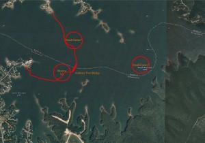
I decided to take a whack at finding this mystery town. Naturally, my first resource was Google Earth. My theory was that the town would probably exist somewhere near where the two rivers met. However, Google Earth offered few clues as to the original pre-dam path of the either rivers.
Finally I did some searches on the USGS website, and came up with pay dirt! USGS had some aerial photos from 1949 that were nearly perfect. The evidence is pretty convincing. You can definitely see man-made structures all over the area, as well as what Google Earth calls the Anthony Ford Bridge (historical site). You can find the photos here. Study the “then and now” shots and see if you can identify the bridge!